
Standard operating procedures cover general guidelines for UAV use.
How PLACE works
PLACE only works with the approval of Government.
Before operations commence PLACE establishes the necessary working arrangements (executed by a memorandum of understanding) defining roles and responsibilities of Government and PLACE.
Once arrangements are established, PLACE works in partnership with Government and approved operators to conduct UAV operations.
Government gains the necessary for approvals required for PLACE operations.
Approvals
Government must gain necessary Civil Aviation Authority (CAA) and Air Traffic Control (ATC) approvals required for the operation of PLACE Aerial. This includes permission to conduct Beyond Visual Line of Site (BVLOS) sorties (PLACE Aerial’s typical range is 10km), as well as conducting missions over built up areas and people. PLACE Aerial’s minimum flying height is 400 ft (122m). When flying over high rise buildings its altitude may reach 180m – 200m. Higher altitudes (i.e. greater than 400 ft and up to 2,000 ft) can be flown subject to CAA approval.
Launch/landing sites
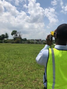
Suitable launch/landing sites must be identified. These should selected to be within proximity to the area being flown and the space needed to land. When selecting launch sites check for potential obstacles nearby, whether man made and natural (a laser range finder is useful to check the heights of objects near launch sites):
Operators must consider the space the UAV needs to land safely based on the nature of the landing e.g. VTOL or belly landing. In cases of a belly landing the actual length of the skid depends on the friction of the terrain. Typically the minimum landing area is 10m by 50m (i.e. a soccer field is sufficient) but to accommodate changes in wind direction 75m by 75m is recommended. Check surroundings for local windbreaks, these will aid in VTOL approaches and landings. Operators are required to prepare a site report for each launch site.
Number of sorties
It is possible to complete 4 flights per day, but a realistic number is 2 – 3 to allow for turnaround times (this includes data downloads, battery changes and the uploading of flight plans). Operators can estimate the duration of their operations based on flight times and number of sorties per day.
Weather conditions
PLACE Aerial must not be operated in inclement weather. Operators must not fly when it is raining. Be aware that weather conditions can change swiftly. If in doubt, do not fly. Operators must be aware of local wind conditions as these impact landing trajectories so use of weather apps (e.g. Windy) and an anemometer is recommended.
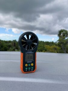
The cruise air speed of the UAV is typically between 16 and 18m/s so it is recommended that wind speed not exceed 10m/s (36 km/hr) to avoid blurring of images. When using the Sony A7ii at 400 ft ground speeds exceeding 25m/s may cause image recording overload and forward motion blur. Hence it is important to eliminate the effect of wind on the ground speed of the UAV by orienting flight lines perpendicular to the prevailing wind direction.
Risk assessment
Risk assessment is a key part of safe drone operations. Operators should take steps to ensure they understand and plan for potential risks. Be aware of aerial risks, including other aircraft, other drones, and territorial birds. Some birds are capable of taking down drones if they feel threatened.
Risks not only come from physical hazards but also from operators themselves, for example operators should not fly if they are fatigued. Before flying operators refer to the IMSAFE checklist covering illness, medication, stress, alcohol, fatigue, and emotion.
In addition to the IMSAFE checklist operators should also use the PAVE checklist to assess flight risks. The PAVE the checklist identifies four categories: Pilot in Command (PIC), Aircraft, enVironment, and External pressures as follows:
- Pilot in Command risks include assessing whether an operator is ready to fly at any given time.
- Aircraft risks include using the wrong aircraft for a given flight, an aircraft that the pilot isn’t familiar with flying, and maintenance issues.
- Environmental risks include weather, terrain, and airspace.
- External pressures on the pilot might include the pilot’s desire to impress someone or to demonstrate their qualifications or the operator’s desire to complete a task quickly.
Operators must prepare a risk assessment plan which identifies risks, their impact, their likelihood of occurrence and the measures to mitigate them. The JARUS Specific Operations Risk Assessment (SORA) which provides a systematic methodology to identify risks associated to a UAV operations can be referred to for this purpose.
Test flights
Test flights are performed to determine the UAV is safe to fly. Test flights are always conducted in a remote location in case of incident and before missions commence. Only the operator and flight personnel must be engaged in test flights.
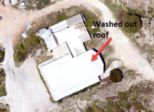
Operators must also check camera settings are optimal for the prevailing light conditions. Operators should test different aperture and shutter speed to ensure images are not overexposed i.e. washed out, as shown below:
Operators should use camera settings taking into consideration the following:
- A high aperture restricts light to the camera sensor resulting in dimmer images. Low apertures result in blurry images. Set the aperture setting to as high as possible.
- A high shutter speed results in brighter images but images will be blurry as the shutter will be open for longer while the UAV is in motion. Conversely lower shutter speeds result in dimmer images. Set capture to fast (low end of the value) whilst allowing for enough light to ensure bright images. Set the shutter speed to 1/1200 seconds or less if the sun is very bright.
- A high ISO means more light in hence brighter images even in poor lighting conditions but images will be grainy in low light conditions. Lower ISO values results in dimmer but sharper images (which us good for direct sun light conditions). Set the ISO setting to no more than 600.
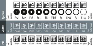
Camera settings and their effects
For a discussion on camera settings, see here.