Aerial images are acquired in JPEG format and are geo-tagged during flight with a dual frequency (L1/L2 bands) RTK receiver, this typically will yield immediate positional accuracies of approximately 5m.
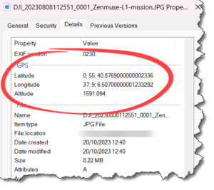
An on-board camera is connected to the UAV’s GNSS receiver so that whenever a picture is taken the location of the exposure event i.e. the action of opening of the shutter, is recorded. This geo-tag may be written to the image’s EXIF header, or to a separate text file, as latitude longitude in the WGS84 Datum. Altitude is also recorded (in meters):

While the UAV is airborne a base station is also logging GNSS readings, these readings are more accurate which allows for corrections to be applied to the UAV’s geo-tags post flight using Post Processing Kinematic (PPK) processing. This improves the positional accuracies of the exposure event to between 20 – 30cm. It is this PPK image product that PLACE makes available to members.
Using a CORS
If a Continuously Operating Reference Station (CORS) is available and within range of operations, GNSS readings from the CORS can be used in lieu of a UAV base station.
What does the geo-tag represent?
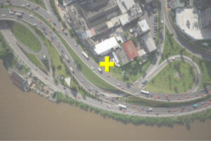
Geo-tagged images are not image maps, they are individual images with a coordinate that nominally represents the image center coordinate as shown by the yellow cross below:

In a GIS however JPEG files must have an associated world file (JGW) so they can be positioned correctly. The format of a JGW file is described here. The center coordinate is not used. In effect this means the GIS thinks that an image acquired from a UAV has no coordinate information. If you were to load an image into ArcGIS or QGIS it would be positioned at coordinate 0,0 (off the coast of Africa) and as all images are interpreted in this way it means all images would lie on top of one another at position 0,0 (aka Null Island).
How to use geo-tagged images?
To make use of these aerial images you need to produce an ortho map. You can do this using an ortho-processing software package like Agisoft MetaShape Pro, Esri’s ArcGIS Reality, Pix4D and SimActive’s Correlator 3D. This process is described in the following sections.
