
The base station is used to provide corrections for GNSS readings from the UAV.
- To set up the base station either permanently mark a point and set up base receiver over the point or if connecting a to geodetic control network going to nearest geodetic control point and set up the base there.
- If the distance between nearest geodetic control point and the rover (UAV) is greater than 10km, a new observed control point should be measured by means of traversing.
- Make sure the base station is placed precisely above the marked point on a tripod and leveled.
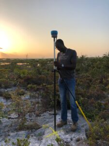
- Check you have recorded the coordinates (datum/projection) for the control point, if needed check with the local geodetic agency.
- Power up the base station, confirming it is operational before leaving its location.
At the end of the day, download GNSS readings, power down the unit and pack away. Make sure you charge the unit overnight.